
AEI-Insights - AN INTERNATIONAL JOURNAL OF ASIA-EUROPE RELATIONS
(ISSN: 2289-800X); JANUARY, 2015; Volume 1, Number 1
Pekka Korhonen
University of Jyväskylä
Department of Social Sciences and Philosophy
FI-40014 University of Jyväskylä
Finland
(During September - 20 December 2014 visiting scholar, Renmin University, Beijing, PRC;
Correspondence preferably with email)
Tel: +358 50 563 1864
E-Mail: pekka.a.korhonen@jyu.fi
The ASEM has been growing steadily in size and scope since its inception in 1996, and will probably continue to do so in the future. This article tries to map both the history of the concepts for depicting the classical continents and their very flexible boundaries, as well as a possible future course for ASEM from a cartographic point of view, especially in regard to the importance of and interest in Africa that most current ASEM members are showing. This is also considered as one of the future recommendable directions of the expansion of ASEM.
Asia; Africa; Europe; ASEM; cartography
I will attempt to combine in this article three completely disparate elements: commenting on the contemporary Asia Europe Meeting (ASEM), on ancient cartography of the old continents, and on the developmental needs of Africa. The result may be confusing, but yet, perhaps, conceptually interesting. This is the way a conceptual historian thinks.
During its brief history ASEM has rapidly evolved from a mid-size international organization in 1996 to a fairly large organization in 2014. In the inaugural meeting in 1996 there were 25 state members, clearly limited to member states of the European Union and the ASEAN+3 formation. The categories of Asia and Europe were clear and undisputable, and it seemed that the two economically and politically strong two extremes of the Eurasian landmass were monopolizing the usages of Asia and Europe (Korhonen, 2007).
.png)
Map1 ASEM 1996
ASEM in 2014, after several rounds of enlargement during the Summits in 2004, 2008, 2010 and 2012 is a fairly large organization with 51 members, 49 of which are states: the 10 ASEAN countries, China, Japan, South Korea, Mongolia, Bangladesh, India, Pakistan, the 27 EU member states, Norway, Switzerland, Australia, New Zealand and Russia. The ASEAN Secretariat and the European Commission are also counted separately as members. In Milan in 16–17 October Croatia is supposed to join, becoming the 52nd member, while Turkey and Kazakhstan are on the waiting list. Many more states, which in terms of formal modern geography would be situated in either Asia or Europe, are still missing from the organization, and as the acceptance rate of new applicants has been rather high in the past, we can reasonably expect that the organization will go on expanding also in the future. Central Asian, Western Asian, Eastern European and some Southeastern European states are still largely empty spaces on an ASEM map.
.png)
Map2 ASEM 2014 by Pekka Korhonen - Modification from Datastat - Modification from Wikipedia. Licensed under Public domain via Wikimedia Commons - http///commons.wikimedia.org/wiki/File/ASEM.PNG#mediaviewer/File/ASEM.PG
At the same time the binary categories of Asia and Europe have become slightly blurred, because geographically peripheral and boundary states have been added. During the 8th ASEM Summit held in 2010 in Brussels Australia, New Zealand and Russia were accepted as members. They were problematic cases in terms of definitional categories, as in Asia there has been a long debate whether Australia and New Zealand could be defined as Asian states, dating to Australian Foreign Minister Gareth Evans’ redescription of the “East Asian Hemisphere” in the 1990’s (Evans, 1995). In the case of Russia the categorical problem was that it is situated both in Europe and Asia, so that it was unclear whether it joins as a “European” or as an “Asian” state, while the EU at that time still reserved the category of Europe only for EU member states. These definitional hurdles were overcome by adding a new category, namely the “Third group” (Gulyaeva, 2012), called also the “Pacific group” (Yeo, 2013). During the 9th ASEM Summit in 2012 in Vientiane, Norway and Switzerland were added, thus again diluting the narrow definition of “Europe” to mean only the EU within the ASEM categories.
There exists a perennial discussion on the importance of ASEM, which has accompanied it since its inception (Bobrow, 1999). As Yeo Lay Hwee recently commented, although the large membership accounts for 60% of the world’s population, 50% of global GDP, and 60% of world trade, it remains relatively unknown among the citizens (Yeo, 2013). The media does not cover the meetings very seriously, comments in media usually are that ASEM cannot achieve very much, and there is also a feeling that national leaders are loosing interest in the organization, one reason being the low level of visibility of the summit meetings, and another the fact that contemporary governance of the world and its regions demands lots of participation in meetings. ASEM has to compete with other organizations and forums for attention during a period, when “principled multilateralism” is giving way to “diminished multilateralism” and “forum shopping”, as Jürgen Rüland argues (2012). International organizations have turned into fora of intensifying power struggles between states aspiring for regional or global leadership roles, and between established and rising powers, or status quo and imperialist powers, as Hans Morgenthau formulated it already in 1935. Forum shopping implies that existing international organizations are shunned, and instead new ones are created, and bilateral forms of interaction are favored against multilateral ones. Of forum shopping Nicolas Sarkozy’s L’Union pour la Méditerranée of 2008 is one example (Balfour et al., 2008); the BRICS after 2006 are another (Keukeleire et al., 2011), and the new Development Bank launched by the BRICS in July 2014 (Xie, 2014; Robles, 2014) are cases in point. Instead of ASEM, the EU and ASEAN can engage in direct dialogue with each other; the EU has direct strategic partnerships with major states like China, India and Japan; all East Asian states as well as the EU are engaging in a multitude of bilateral free trade agreement negotiations, a number of which have also been concluded during the past years.
There are of course also attempts to invigorate the ASEM summits, to maintain their momentum and increase their importance among institutions of global governance. These include attempts to make the meetings less bureaucratic, producing fewer and shorter papers requiring less haggling, and to arrange a “retreat” session for national leaders, where they can discuss relatively freely among themselves (Islam, 2014). The open conflict in Ukraine with EU sanctions against Russia is also a clear problem for ASEM now that Russia is a member, but apparently Italy as the chair attempts to keep the ASEM structure intact, specifically trying to ensure that also President Vladimir Putin will attend the conference (Interfax, 2014).
However, perhaps the main importance of ASEM does not lie in the summits. Unlike many other large interregional institutions, ASEM has systematically tried to construct a deep structure for the interaction, including various ministerial meetings, business leader meetings, and meetings of civil society organization representatives. The Asia Europe Foundation (ASEF), Asia Europe Journal (AEJ), and Asia Europe Institute (AEI) are all important fora for the exchange of culture, understanding, ideas, and scholarship, all with a vision over immediate political concerns and day-to-day politicking. ASEM’s long-term importance may rather lie in its broad level of institutionalization, rather than with the summits.
Even the brief history of ASEM shows that temporal political constellations and decisions influence geographic categories, rather than vice versa. On a longer historical perspective we can say that the formation of geographic regions, especially their boundaries and peripheral areas, or what belongs to which category and what somewhere else, is historically a haphazard process, depending primarily not on geographic characteristics, but rather more on political and economic, but sometimes also on cultural, climatological, religious, and perhaps even artistic circumstances—in the sense that cartographers are individuals, who also have an aesthetic sense. We could take a look at the origin of the concepts of Asia, Africa and Europe to open more the possibilities of understanding the potentialities in the interpretations of these concepts. They could mean much more that they happen to nowadays, and old meanings can acquire new importance as a basis for political arguments in such expansion prone organizations as ASEM. Irrespective of the future importance of the summits, the larger organization itself could remain important for managing the vast trading regime, which maintains the momentum for adding new members during the following decades. The emergence of Africa as an important trading region should be of interest also for ASEM in the future.
Unlike often thought, originally Asia, Africa and Europe were not European concepts, but rather Eastern Mediterranean geographic names, which at the time of the birth of continental thinking was a distinct cultural region of its own. Only quite recently, during the nineteenth century, have they become commonplaces in the entire world. They are best analyzed as synecdoches, which represent larger narratives, while as names they also become established by being used within narratives. The basic plot of old Greek narratives follows the geopolitical structure of civilization developed by Mircea Eliade in his Cosmos and History, first published in 1959. The centre of the world is depicted as a culturally based cosmos, where normal and normative human beings dwell, and around it are situated zones of increasingly miraculous beings. In the ancient Mediterranean world there was variation whether the centre was based in Egypt, which was considered as the origin of civilization, or in a contemporary political centre, such as Athens, or later Rome. This issue was never settled in ancient literature.
One of the origins of the names Asia and Europe has been traced back to the language of the Akkadian empire around 2500 BC, where asu referred to the rising sun, and erebu to the setting sun (Klein, 1966). Akkad was a Semitic language belonging to nomads living in Arabia and the Zagros Mountains. They invaded and conquered the collection of Sumerian city states in the lower reaches of the Euphrates and Tigris, and the empire of King Sargon (2334–2279 BC) which extended west to the Mediterranean. We do not know where Sargon’s capital Agade was situated, but it probably was somewhere in the Sumerian heartland, where most of the population and wealth were concentrated. If you looked from there to the east in the morning, you might have seen the sun rise behind the Zagros Mountains, while it set in the west in the lands, where Jews and Phoenicians later built their kingdoms. Etymological research cannot by its nature establish undisputable truths, the asu-erebu pair is only a logical guess. Even less is known how the words were incorporated into Mesopotamian geographic theories as names for continents, but during the following two millennia they spread widely through the region. The Lydians, Medians, and Persians used these names and eventually also Ionian Greeks learned them. We do not know when this cosmological construction of the world took place, but even in Greek the concepts are so old that two millennia after Sargon they were woven into Greek myths of the origin of the world.
The study of continental metaphors normally starts with Greek literature. The Greeks did not know where the idea of dividing the world into continents came from, but Strabo suspected that the origin lay in the fact that general names were needed for Greek lands facing each other over the Aegean Sea. A number of Greek villages, towns and city-states existed in both the eastern and western coasts of the Aegean, and Europe and Asia served as useful regional names (Strabo 1968I.4.7.). Inhabitants around the Aegean would thus have applied the originally Semitic words Asia and Europe to their own living environment. The division was thus an intra-Greek affair, because it was used in separating Greeks living in Hellas from Greeks living in Anatolia. It is in this sense that Herodotus presented the Persian argument that European Greeks invaded Asia when they attacked Troy (Herodotus 1990 I, 4).
It seems, nevertheless, that the names were eventually adopted as parts of the general Greek cosmology and the area of the continents was extended over the whole known world, with a third continent, called Libya at that time, added to the list quite early. The earliest surviving literature already told about places as distant as southern Egypt. Even though the concepts were not as important as they are nowadays, they formed an interesting intellectual puzzle, and among historians there was an ongoing debate about the boundary separating Asia from Europe, and Asia from Africa. The Aegean was a clear area of continental division, but there was no general agreement where the boundary might lie farther to the north. The Mediterranean neatly separated Libya/Africa from Europe, but the demarcation in the southeast was debatable. The debate was never solved during the millennia of classical Greek civilization, which later enabled various innovative redescriptions by Roman and Christian authors. Of course, the boundary issue is unsettled even nowadays (Lewis & Wigen, 1997).
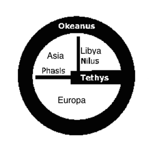
The Homeric and Hesiodic legends, dating from about 700 BC, were authoritative cosmological sources for later Greek thinkers. Strabo considered Homer to have been the founder of the science of geography, because he explained the general shape of the world, and established its basic divisions (Strabo 1968I, 2-11). Because of the importance of Egypt, the Nile was considered to be the greatest and most venerable of all rivers. Ethiopians were thought to be living on the southern side of Egypt, occupying the whole southern part from the sunrise to the sunset, and because their living places were separated by the Nile, they were thus considered to be living in two places (Homer 1995I, 22-24). Strabo interpreted this to mean that Homer considered the Nile to be the first continental divide, although he did not yet name the continents. At the opposite side of the world dwelled Nomads in the north. These two peoples inhabited the climatological extremities, while ordinary people lived in the middle, along the coasts of Tethys, with which we can understand not only the Mediterranean, but all expanses of salty water sailed by the Greeks from Gibraltar to the Black Sea. The basic geographic division of the world in Homeric literature was thus made along the climatological south-north dimension.
In a fragment of Aesculus a definition of the boundary between Europe and Asia was given as the mighty river Phasis (Aeschylus, 1992, Fragment 106). There are many small rivers flowing from the Caucasus Mountains to the Black Sea, and it would be impossible to say which one of these actually was meant. The Phasis was above all a mythical river, the end of the sailing of the Argonauts, and a mighty stream at the end of Tethys was necessary for the Greek cosmography. If there was to be a geographic division of the world, it necessarily had to relate somehow to the two existing magical bodies of water, Tethys and the Nile, i.e. the division had to run as a logical continuation of either of these waterways. Tethys ran from west to east, and the Nile from south to north. The Aeschulian solution was to concentrate on the west-east direction, and elevate Phasis to a rank similar to the Nile, as a wide stream dividing two continents from each other. This is the oldest mentioned boundary between Asia and Europe. A little later Hecateus seems to have separated the western peninsula of Asia into a special continent called Libya; the boundary naturally lying along the Nile (Strabo 1968I, 11-12). Thus we have arrived at the classical division of the old world into three continents.
For Herodotus, Libya was a blessed place, because its eastern end was in Egypt, the seat of ancient civilization and abundant harvests. Nowhere in the world were there as many marvellous things and so many works of unspeakable greatness as in Egypt. Ethiopia to the west of Egypt was not a bad place either. There was plenty of gold in Ethiopia, as well as elephants, woodland trees and ebony. The people were the tallest, fairest and longest-lived of all men (Herodotus 1990 III, 113).Nevertheless, nothing could surpass the greatness of Egypt itself. For instance, the greatest king of all history had been Sesostris, king of Egypt, whose empire had reached from Ethiopia in the west to Arabia in the east, and to Europe in the north (Herodotus 1990 II, 102-110).
Asia seemed to be a place similar to Libya, but perhaps smaller. Asia was so small that it was basically covered at any time by a single empire, like those of the Median, Scythian and Persian empires, which all were said to have encompassed all Asia (Herodotus1990 I, 104-6, 130). Likewise, Alexander the Great was also said to have ruled all Asia. Asia was inhabited from the eastern banks of the Nile all the way to India, but after India there existed only uninhabited deserts, and Herodotus did not have any information about them, or what lay beyond them. Anyway, he did not think that Asia would extend far to the east (Herodotus 1990 IV, 37-41). Thus, nearly all of the Asia of Herodotus was composed of a few civilized kingdoms. It was the wealthiest of all the continents, and besides the eastern deserts, with nothing residual imposed on its area.
Europe was the greatest anomaly, because it seemed to be indefinitely vaster than the other two continents. It spanned the length of them both, and no one knew where it ended, either in the west, north, or east (Herodotus 1990 IV, 45). Europe thus contained all residual land that could not be meaningfully placed into the other two continents, which is a clear indication that although Europe was geographically meaningful, culturally it was a rather unnecessary category. It was the most unknown of continents, and practically all of it represented peripheral chaos in the Eliadean sense, except the areas settled by the Greeks themselves. Most of Europe was populated by Scythians. The general term Scythian was not an ethnic denomination, but rather described a way of life, that of nomadic people moving around after pasture with their herds of horses, cows and sheep over the grasslands and forests of Europe, living in wagons and light dwellings, seldom building towns, except on the coast, where they could get additional income from robbery and trade. Thus within the Greek cosmology Europe was an unbounded vast region inhabited by wild barbarian tribes, cannibals and mythical beings. Excepting Greece, Europe was essentially a place without history.
Asian history, instead, was political. It was a grand narrative of succeeding political organizations, with Lydians, Medians and Persians fighting alternately for grand empires.With Alexander’s conquests, Greek awareness of the east expanded, and especially India, which Alexander was not able to conquer, became during the following centuries a land of mythical proportions. Travellers, ambassadors and merchants visited India and told various tales of it. Strabo already reported from his own trip up the Nile in 25–24 BC that annually about 120 ships sailed from the Arabian Gulf to India, many of them financed by Alexandrian merchants (Strabo 1968II, 5, 12).
Map4 The world according to Strabo
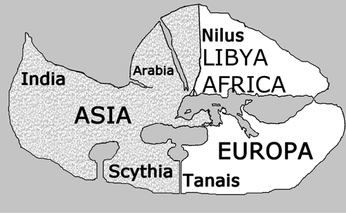
Strabo (64/63 BC–c. AD 24) divided the world differently from the earlier classics. He decided to present Europe as a small continent. That meant adopting a new river as the boundary between Asia and Europe. The mythical proportions of the Phasis had dwindled during the centuries of travel, while the Tanais (Don) truly was a big river, so that it was more suitable as a continental boundary. Strabo was a Roman citizen, and although Rome was an intercontinental empire, the origin and capital of Rome was clearly in Europe, so it was not politically feasible to present Europe simply as vast unknown barbarity. Strabo argued that the valleys in Europe produced peaceful people interested in good administration, while mountains provided for fierce warriors. Europe thus had an ample supply of both elements, a warring spirit for military expansion and an ordering spirit for the administration of the lands conquered. Strabo’s examples were the Greek, Macedonian, and Roman empires (Strabo 1968II, 4, 5-7).
Strabo was able to use good geographic information in writing his geography, and thus he was of the opinion that the Red Sea would have been the most logical boundary between Libya and Asia (Strabo 1968I.2.28), but in the end he decided to agree with the ancient definition and to keep the Nile as the eastern boundary of Libya. Everything to the east of Europe and Libya was Asia, so that Asia became the biggest of all continents, occupying half of the known world (Strabo 1968II.5.26). Notwithstanding, Asia remained the most exalted continent even in his account. For instance, he reported the barbarous customs of Scythians in his narratives of Europe, even though a large portion of the Scythian lands had now been allocated to Asia. Strabo also placed in Asia the only place on earth that exceeded Rome in blessedness, and that place was India. Strabo called it the greatest of all nations and happier than any other (Strabo 1968II.5.32). The western boundary of Asia could not be defined clearly except by naming the rivers; the origins of the Nile and the Tanais were unknown, and both rivers could simply be extended all the way to the surrounding world ocean. It can thus be argued that on the whole the geometry of continental thinking had not changed much, only the Euro-Asian boundary had been shifted to run from the south to north.
The Greek debate on the continental boundary did not end with Strabo. Procopius of Cesarea, a Greek historian, who lived in Eastern Rome in the sixth century AD, summarized both arguments in his History of the Wars, pointing out that some authors demanded that the boundary had to be understood as a continuation of Nile, while others maintained that the Euro-Asian boundary had to be understood as a continuation of the Mediterranean in the eastwards direction (Procopius 1993VIII, vi, 1-12). He offered no conceptual solution to the thousand year long debate, because both arguments had been presented so many times by different authors. Empirical exploration seemed to offer the only solution, the practical discovery of the real waterway that actually separated the continents. Nevertheless, the kind of definitive solution to determine the boundary of Asia and Europe by way of exploration was never actually attempted. The problem was not considered very important.
Roman thinking was definitively less global than Greek thinking, usually being confined to the Roman Empire and adjacent regions, not trying to encompass the whole world. Most Roman authors treated Asia only as a Roman province at the western end of Anatolia. The main continental change they made was the renaming of the southern continent as Africa, according to a Roman province there. They transmitted the Greek ideas to later periods, though, by preserving Greek geographic literature as translations into Latin, an example being Pomponius Mela’s De Chorographia. Similarly, Medieval Europeans were not interested in continental geography. They were peripheral people, staying for the most on their own habitat, and their main cosmological concepts were religious, not geographic. Of course the production of mappaemundi started during the late Middle Ages in connection with the Crusades, but their simple schematic nature clearly displays the lack of definite geographic knowledge of the world.
It is only during the period of explorations from the fifteenth century onwards that the continental divisions of the world again became intellectually important. This is especially true for Portuguese explorers, who sailed along the African and American coasts, in the Indian Ocean, in Southeast Asian waters, and in the Western Pacific. Duarte Pacheco Pereira’s (14??-1533) Esmeraldo de Situ Orbis is important in this sense. He was one of the most important Portuguese seafarers, making exploratory journeys in Brazil, the African coasts and India. As Joaquim Barradas de Carvalho shows, Pacheco Pereira’s treatise finely amalgamates classical learning from Homer onwards, Christian cosmology, and contemporary Portuguese empirical observations of four different continents (Barradas de Carvalho, 1968).
Map5 The world of Pacheco Pereira, early 16th Century
Pacheco Pereira used the three classical names, Europa, Asya and Africa, separated from each other by the usual Mediterranean, Don and Nile, as said in classical books. He did not actually, however, think of them as continents, as on the basis of Biblical evidence he thought that most of the earth had to be dry, sea being only a large salty lake bounded on all sides by land. Most of it was thus far unknown. The Brazilian coast that he had visited was part of this outer land crescent. Martin Waldseemüller published in 1507 his map Universalis Cosmographia, where he gave for the fourth continent the name America in honour of the Italian explorer Amerigo Vespucci, who financed at least part of the drawing of the map. This is the time when Duarte Pacheco Pereira was writing his manuscript, but apparently he was not aware of Waldseemüller’s map.
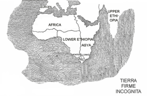
Africa and the Nile were of most interest to Pacheco Pereira, because he knew that region best, while Europe was of no apparent interest to him, except that he already oriented his cartographic thinking towards the north, and thus Europe becomes the uppermost continent in visualizations of his thinking. He thought that theoretically he had understood where the origin of the Nile was. As Ptolemy had suggested, and as had been accepted in much medieval literature, the origin of the Nile was supposed to be in the Montes Lunae (Mountains of the Moon), a long way south from Egypt, so that the flooding pattern of the Nile in summer when there was little or no rain in Egypt could be explained. Because the Nile was the boundary between Asia and Africa, the Montes Lunae theoretically had to lie at the southern end of the land; otherwise the river could not have served as a proper boundary. Thus Pacheco Pereira logically thought that they had to be the rocky mountains seen while sailing past the Cape of Good Hope. From there the waters then flowed along two main courses, one of them entering the sea in the west as the Senegal and Niger rivers, the other course flowing to the Mediterranean as the Nile (Pacheco Pereira 1937, 16-7, 78, 80, 154-5). This conceptualization meant that as soon as the Portuguese sailed around the Cape of Good Hope, they entered Asia.
However, as Homer had already told 2,200 years before Duarte Pacheco, all land south of Egypt was also called Ethiopia. Duarte Pacheco also recognized two Ethiopias, or sometimes three. The Lower Ethiopia extended on the southern side of the Senegal River all the way to the Indian Ocean. The other Ethiopia was called Upper Ethiopia, and it began at the Indus east of the great kingdom of Persia, and then extended eastwards, without a specific eastern boundary (Pacheco Pereira 1937, 78-9). It is thus impossible to find any special conceptual difference between Asia and Ethiopia, except that perhaps Ethiopia was a larger concept. Or perhaps we should say that Ethiopia unified Asia and Africa into one region, covering most of them both, at least as seen from the perspective of southern seas.
Duarte Pacheco was not the only Portuguese explorer who used the concepts in this way. Fernão Mendes Pinto’s (1509-1583) Peregrinação (Pilgrimage) is the most famous Portuguese travelogue, translated into various European languages. It was an autobiography, dealing with the travels of Pinto himself as an adventurer and occasional pirate for over 21 years in eastern waters, written during the 1570s, and published posthumously in 1614. It is a colourful book, describing the adventures of the protagonist during alternating fortunes and misfortunes in various eastern kingdoms. Because it is written in the form of a memoir, it is impossible to ascertain the truthfulness of the narratives, and it has the fame of a book full of lies, similar to de Mandeville’s Travels. Nevertheless, perhaps the book resembles even more John Bunyan’s The Pilgrims Progress, written in 1678. Both books are deeply religious works describing unwavering Christian faith through a string of changing fortunes in strange lands. The name Peregrinação also refers to this aspect. Notwithstanding, it is an interesting book, and its advantage is that it was written by a truly non-scholarly person, presenting language that probably was used among common Portuguese adventurers at the time. In his first chapter Pinto explains that he had travelled all over within the boundaries of Asia, listing its places as ‘Índia, Etiópia, Arábia Feliz, China, Tartária, Macáçar, Samatra e outras muitas províncias’ (Pinto, 2001, 23). Thus, again we see Ethiopia and Asia occupying at least partly the same space; they belong together.
Pinto never specifies his geographic regions, so that we are not able to say anything specific about their locations or boundaries; we can only notice the association. However, what we can say is that for the first 2,300 years of the continental conceptualizations of the three old continents, the boundary between Asia and Africa laid on the Nile, rather than on the Red Sea, and as a large regional concept, Ethiopia blurred the boundary between these two. Similarly, we can also observe that the boundary between Asia and Europe has been equally contentious. Of course lots of defining and boundary making has taken place during the past 500 years—but a mere half of a millennium is actually a rather short time.
When one reads publications by international developmental organizations for Africa, there are strong signs of positive economic performance in the continent, although mostly the argument about true development at the citizen level is still about future possibilities. Anyway, numerically good economic growth has taken place there for the past twenty years, picking up during the past ten years, and in 2013 Africa was the second most rapidly growing macro region in the world, at 4.7 percent, overtaken only by Southeast Asia and the Pacific, which grew by 7.2 percent. Both figures were well above the world average, which was only 2.4 percent (World Bank, 2014). In statistical macro figures, Africa is thus doing well nowadays. Most of this growth is lead by investment, which is pouring in not only from the traditional donors Europe and the USA, but also from China, Japan, Korea, India, Russia, Brazil, and elsewhere (UNECA, 2013), most of these countries being ASEM members. Investment goes mostly on the extraction of basic commodities, especially oil and minerals, and on building infrastructure, but food production is also one target. Fairly robust growth takes place also in the service sector, where tourism industries are expanding, and investment in transport, telecommunications, and banking is growing. Much of the incoming capital flows go to countries with rich natural resources, such as Angola, Mozambique, Sierra Leone and the Democratic Republic of Congo, but also to countries with poorer resource endowments, such as Ethiopia and Tanzania (World Bank, 2014).
Problems connected with this growth are that it has not been markedly facilitating African industrial development, nor has it yet been very effective in linking Africa into international chains of production, except at the stage of exporting natural resources. Global value chains, based on offshoring, outsourcing, and in general on the role of intermediate goods in modern production networks, are concentrated on East Asia, Europe, and North America, and Africa is mostly outside of them. Its share is small, and increasing only on a minuscule pace, from 1.4 percent to 2.2 percent between 1995-2011 (AfDB et al 2014, 13). Besides the natural commodities, the potential African advantage is its growing young work force, which is mostly stagnant or shrinking in other parts of the world, such as in China, whose population growth is coming to an end, while wages go on rising rapidly (Yi et al 2013). This leads to the famous thesis by Vandana Chandra, Justin Yifu Lin, and Yan Wang, according to which several millions of light manufacturing jobs could find their destination in Africa in the near future. According to their figures, China alone employs 85 million workers in its manufacturing sector. A fair share of them will lose their price competitiveness fairly soon. If we add Brazil, India and Indonesia, we get some 40 million workers more in global manufacturing, and these jobs are later during the coming decades expected to locate somewhere else. Of course all manufacturing jobs would not be relocated, but if China relocated to Africa only 10% of its jobs requiring only unskilled low wage workforce, or 8.5 million jobs, this could double the amount of African labour force in manufacturing (Chandra et al., 2013, 77). As light manufacturing has historically been afforded a crucial role in jumpstarting latecomer countries towards the process of industrial development (Korhonen, 1998, 48-66), this opens a rather hopeful horizon for Africa’s future.
However, as the African Development Bank warns, this kind of horizon is not a destiny. It is only a possibility, which may not be realizable. Technological developments, such as robotics and 3D printing, can erode the cost effectiveness of unskilled cheap labour, and keep or redirect simple manufacturing processes to traditionally industrialized countries (AfDB et al., 2014, 14). Yet, neither are these pessimistic possibilities a destiny. With education, state-led industrial policies, creation of reliable administrative and physical infrastructure, including a sufficient electricity supply, and infusion of capital and know-how, speeding up Africa’s industrialization and linking it deeper into the multilayered world economy is completely possible (UNECA et al., 2014). In the long run we probably could be rather optimistic about African development, but we cannot really yet know during which of the future decades we will actually see tangible results of all this.
There is nowadays also a lot of conferencing taking place in and around Africa. Japan started it early in 1993 with the Tokyo International Conference on African Development (TICAD) series, with follow-ups in 1998, 2003, 2008 in Tokyo, and in 2013 in Yokohama. These were large-scale meetings since the beginning, and developed eventually into systematic summit meetings. Connected with TICAD, Japan initiated with Indonesia also the Asia-Africa Forum (AAF), with meetings in 1994 in Bandung, in 1997 in Bangkok, and in 2000 in Kuala Lumpur. The EU and China followed in 2000. The European Union has had summit meetings (EU-Africa Summits) with African heads of states in 2000 in Cairo, in 2007 in Lisbon, in 2010 in Tripoli, and in 2014 in Brussels. China similarly established the Forum on China–Africa Cooperation (FOCAC) in 2000 in Beijing, follow-ups taking place in 2003 in Addis Ababa, in 2006 in Beijing, in 2009 in Sharm El-Sheikh, and in 2012 in Beijing. China started also in 2003 a specific ministerial level Fórum para a Cooperação Económica e Comercial entre a China e os Países de Língua Portuguesa (Forum Macau) with Portuguese speaking countries, four of which are in Africa: Angola, Cape Verde, Guinea Bissau, and Mozambique (Tavares Martins, 2014). Follow-ups have taken place in 2006, 2010 and 2014. India followed in 2008 in the form of the India–Africa Forum Summit in New Delhi, followed by another summit in 2011 in Addis Ababa. The United States has been rather late in focusing on Africa; the inaugural United States–Africa Leaders Summit took place in Washington D.C. in August 2014 (Usman, 2014). Lots of other international conferencing is also taking place regarding Africa and its individual states. Many of these meetings have nowadays a structure resembling that of ASEM, with at least business forums and sometimes also civil society forums connected with them.
There has not been this much international interest in Africa since the days of the European Scramble for Africa in the 1880s. Because most states interested in cooperation with Africa are simultaneously ASEM members, and ASEM seems to be growing larger in practically every meeting, ASEM could in the future take also Africa on its agenda. Because Africa is the focus of so much interest now, and because its needs for infrastructural investment are immense, beginning with the Grand Inga Dam on the Congo river (Taliotis et al., 2014), a concerted international effort, with lots of publicity, would better ensure that also social and environmental aspects are taken care of in this kind of mega project. EU’s policies towards Africa have in the past suffered from the fact that they have been used also as a venue for European self-aggrandizement in the form of projecting its norms on weaker actors in a paternalistic manner (Scheipers et al., 2008). On the other hand, the EU does not behave in this way towards strong actors, such as China, except on a minimal verbal level (Keukeleire et al., 2011). As Mikael Mattlin puts it, these kinds of policies towards big powers are “dead on arrival”(Mattlin, 2012). This may be diminishing, as the prime minister of a major European state has already started preaching against liberalism (McNamara, 2014). Anyway, a concerted effort within the ASEM framework towards Africa probably would balance and harmonize European and Asian approaches, while simultaneously providing economic and technological basis for effective developmental drives towards Africa. As we saw in our review of the development of the concept of Asia, there is historically no definite boundary between the two regions; the same terms, Asia and Ethiopia, sometimes covering large areas of both since the time of Homer. As ASEM seems to be bound on becoming bigger and bigger, making it truly big might be the best strategy for ensuring its continuing relevance in today’s world governance.
Map 6 ASEM 2035?by Pekka Korhonen - Modification from– “LocationEurasiaWithoutIslands”. Licensed under Public domain via Wikimedia Commons - http://commons.wikimedia.org/wiki/File:LocationEurasiaWithoutIslands.PNG#mediaviewer/File:LocationEurasiaWithoutIslands.PNG
Aeschylus (1992) [499-455 BC] Aeschylus, Vol II, Agamemnon, Libation-Bearers, Eumenides, Fragments, Loeb Classical Library, Cambridge, Mass. and London: Harvard University Press.
African Development Bank, Development Centre of the Organisation for Economic Co-Operation and Development, and the United Nations Development Programme (2014) African Economic Outlook 2014. Global Value Chains and Africa’s Industrialisation. Retrieved August 7, 2014, from http://www.africaneconomicoutlook.org/fileadmin/uploads/aeo/2014/PDF/Thematic_Edition/Edition_Thematique_EN_web.pdf
Balfour, R., & Schmid, D. (2008). Union for the Mediterranean, disunity for the EU. European Policy Centre, Policy Brief. Retrieved August 7, 2014, from http://www.epc.eu/documents/uploads/235206674_Union%20for%20the%20Mediterranean.pdf
Barradas de Carvalho, Joaquim. (1968). As fontes de Duarte Pacheco Pereira no “Esmeraldo de situ orbis”, São Paulo: Coleção da Revista de História.
Bobrow, D. B. (1999). The US and ASEM: why the hegemon didn’t bark. The Pacific Review, 12(1), 103–128.
Bunyan, John [1678] The Pilgrim’s Progress From This World to That Which is to Come; Delivered under the Similitude of a Dream. Retrieved February 17, 2009, from http://www.ccel.org/ccel/bunyan/pilgrim.txt
Chandra, V., Lin, J. Y., & Wang, Y. (2013). Leading Dragon phenomenon: new opportunities for catch-up in low-income countries. Asian Development Review, 30(1), 52–84. Retrieved July 30, 2014, from http://www.mitpressjournals.org/doi/pdf/10.1162/ADEV_a_00003
Eliade, M. (1959). Cosmos and History. The Myth of the Eternal Return. New York and Evanston: Harper Torchbooks.
Evans, G. (1995). Statement by Senator Gareth Evans, Australian Foreign Minister, to the ASEAN PMC 7+1 Session, Bandar Seri Bagawan, 2 August 1995. Australia, ASEAN and the East Asian Hemisphere. Retrieved August 1, 2014, from http://www.dfat.gov.au/archive/speeches_old/minfor/gebrune2.html
Gulyaeva, O. (2012). Russia Joins Asia-Europe Meeting: A New Round of the EU-Russia Economic Relations. International Journal of Humanities and Social Science 2(9), 127–135. Retrieved July 30, 2014, from http://www.ijhssnet.com/journals/Vol_2_No_9_May_2012/13.pdf
Herodotus (1990) [c. 440 BC] Herodotus, Loeb Classical Library, Cambridge, Mass. and London: Harvard University Press.
Homer (1995) [700 BC] The Odyssey, Loeb Classical Library, Cambridge, Mass. and London: Harvard University Press.
Interfax (2014, July 10). Putin invited to Milan forum. Retrieved August 3, 2014, from http://www.interfax.com/newsinf.asp?id=519606
Islam, S. (2014, July 14). OPINION: Why Asia-Europe Relations Matter in the 21st Century. Inter Press Service. Retrieved August 1, 2014, from http://www.ipsnews.net/2014/07/opinion-why-asia-europe-relations-matter-in-the-21st-century/
Keukeleire, S., Mattlin, M. et al. (2011). The EU Foreign Policy Towards the BRICS and Other Emerging Powers: Objectives and Strategies (ad hoc study). Brussels: The European Parliament. Retrieved July 5, 2012, from www.europarl.europa.eu/committees/en/studiesdownload.html?languageDocument=EN&file=49151
Klein, E. (1966). A Comprehensive Etymological Dictionary of the English Language, Amsterdam, London, New York: Elsevier.
Korhonen, P. (1997). Monopolizing Asia. The Politics of a Metaphor. The Pacific Review 10(3), 347–365. Anthologized in Peter W. Preston (ed.) Political Change in East Asia, Ashgate: Aldershot, 2003.
Korhonen, P. (1998). Japan and Asia Pacific Integration. Pacific Romances 1968–1996, London and New York: Routledge.
Lewis, M. W., & Wigen, K. (1997). The Myth of Continents. A Critique of Metageography. Berkeley, Los Angeles and London: University of California Press.
Mandeville (1900). The Travels of Sir John Mandeville, Project Gutenberg. Retrieved August 14, 2014, from http://www.gutenberg.org/ebooks/782
McNamara, T. (2014, July). Is Hungary’s Viktor Orban a miniature Vladimir Putin?. Policy Review. Retrieved August 1, 2014, from http://www.policyreview.eu/is-hungarys-viktor-orban-a-miniature-vladimir-putin/?utm_source=MailingList&utm_medium=email&utm_campaign=PolicyReviewEu+newsletter+06%2F08%2F14
Mattlin, M. (2012). Dead on arrival: normative EU policy towards China. Asia Europe Journal 10, 181–198. Retrieved August 15, 2014, from http://link.springer.com/article/10.1007%2Fs10308-012-0321-7#page-1
Mela, Pomponius [43-44] De Chorographia. Retrieved February 10, 2009, from http://www.ancienttexts.org/library/latinlibrary/pomponius.html
In English: Pomponius Mela (1998) Pomponius Mela’s Description of the World, Ann Arbor: University of Michigan Press.
Morgenthau, H. (1935). Théorie des sanctions internationals. Revue du droit international et de legislation comparée, troisieme serie, tome XVI, 474–503 & 809–836.
Pacheco Pereira, D. (1892) [c. 1505-8] Esmeraldo de Situ Orbis, Lisboa: Imprensanacional. Retrieved July 11, 2009, from http://openlibrary.org/b/OL6361165M/Esmeraldo-de-situ-orbis
English translation: Pacheco Pereira, Duarte (1937) Esmeraldo de Situ Orbis, London: The Hakluyt Society.
Pinto, F. M. (2001) [1614] Peregrinação, Lisboa: Viagens
Pinto, F. M. (1692) The Voyages and Adventures of Ferdinand Mendez Pinto, A Portugal, During his Travels for the space of one and Twenty Years in The Kingdoms of Ethiopia, China, Tartaria, Cauchinchina, Calaminham, Siam, Pegu, Japan, and a great part of the East-Indies. With Relation and Description of most of the Places thereof; their Religion, Laws, Riches, Customs, and Government of the time of Peace and War. Where he five times suffered Shipwrack, was sixteen times sold, and thirteen times made a Slave. Written Originally by himself in the Portugal Tongue and Dedicated to the Majesty of Philip King of Spain, London: Richard Bently, Jacob Tonson, Francis Saunders, and Tho. Bennet. Retrieved February 17, 2009, from http://shinku.nichibun.ac.jp/kichosho/main_control.php?FN=pinto&N=Pinto,Fernao%20Mendes.&T=The%20voyages%20and%20adventures%20of%20Ferdinand%20Mendez%20Pinto.1692.&L=e&SH=metadata
Procopius (1993) [545-553 AD] History of the Wars, Loeb Classical Library, Cambridge, Mass. and London: Harvard University Press.
Robles, M. T. A. (2014, July 31). BRICS lay a foundation but will there be concrete action?. East Asia Forum. Retrieved August 1, 2014, from http://www.eastasiaforum.org/2014/07/31/brics-lay-a-foundation-but-will-there-be-concrete-action/
Rüland, J. (2012). The rise of “diminished multilateralism”: East Asian and European forum shopping in global governance. Asia Europe Journal (9), 255–270. DOI 10.1007/s10308-012-0311-9.
Scheipers, S. & Daniela, S. (2008). Empowering Africa: normative power in EU–Africa relations. Journal of European Public Policy, 15(4), 607–623, DOI: 10.1080/13501760801996774.
Strabo (1968-82) [7-24 AD] The Geography of Strabo, 8 vols, Loeb Classical Library, Cambridge, Mass. and London: Harvard University Press.
Taliotis, C., Morgan, B., Manuel, W., Dolf, G., & Mark, H. (2014). Grand Inga to power Africa: Hydropower development scenarios to 2035. Energy Strategy Reviews 4, 1–10. Retrieved August 15, 2014, from http://dx.doi.org/10.1016/j.esr.2014.01.001
Tavares Martins, N. (2014). China’s Rhetoric and Soft Power Towards the Portuguese-Speaking Countries: The Case Of Angola, Master’s thesis, Department of Social Sciences and Philosophy, University of Jyväskylä. Retrieved from http://urn.fi/URN:NBN:fi:jyu-201409302906
United Nations Economic Commission for Africa (2013) Africa–BRICS Cooperation: Implications for Growth, Employment and Structural Transformation in Africa, Addis Ababa: Economic Commission for Africa. Retrieved August 7, 2014, from http://www.uneca.org/sites/default/files/publications/africa-brics_cooperation_eng.pdf
United Nations Economic Commission for Africa & African Union (2014) Economic Report on Africa 2014. Dynamic Industrial Policy in Africa, Addis Ababa: Economic Commission for Africa. Retrieved August 7, 2014, from http://repository.uneca.org/unecawebsite/?q=eroa#.U-tVfoB_vZo
Usman, Z. (2014, August 12). Obama’s Africa summit: Too little, too late?. Al Jazeera. Retrieved August 15, 2014, from http://www.aljazeera.com/indepth/opinion/2014/08/obama-africa-summit-too-little--201481295431885543.html
Waldseemüller, M. (1507). Universalis Cosmographia. Retrieved August 10, 2011, from http://en.wikipedia.org/wiki/Waldseemüller_map
World Bank (2014, April). Africa’s Pulse, An analysis of issues shaping Africa’s economic future, 9. Retrieved August 13, 2014, from Africa Pulse volume 9 - World Bank
Xie, Y. D. (2014, July 29) ’What happens in China, doesn’t stay in China’, East Asia Forum. Retrieved July 30, 2014, from http://www.eastasiaforum.org/2014/07/29/what-happens-in-china-doesnt-stay-in-china/
Yeo, L. H. (2013, May). Towards a Dynamic Asia Europe Meeting (ASEM)? EU Centre in Singapore, Working Paper No. 14. Retrieved July 30, 2014, from http://www.eucentre.sg/wp-content/uploads/2013/06/WP14-ASEM.pdf
Yi, Z., John, K., & Zai, L. (2013). China facing a declining working-age population’, East Asia Forum Quarterly 5(1), 16–18. Retrieved August 13, 2014, from http://www.eastasiaforum.org/quarterly/#
Last Update: 24/12/2021